
Ross McDonnell, NPA Treasurer
The NPA State Council recently approved an exciting new project which will enhance the NPA’s advocacy role for increasing conservation measures in central and western NSW.
The project was established through the NPA Landscape Conservation Forum (formerly the reserves committee) and relates to the NPA Strategic Plan priority to ‘implement a protected area plan for the precious bioregions and waterways west of the Great Divide’.
The project builds on previous actions by the NPA in western NSW. In 1992 the NPA facilitated research which resulted in the Morgan and Terry Report which created maps and details highlighting conservation priority areas across western NSW. Another example is the NPA West Program in 2007-2009 which involved implementing various strategies and themes with one outcome being the successful creation of River Red Gum reserves in south-western NSW.
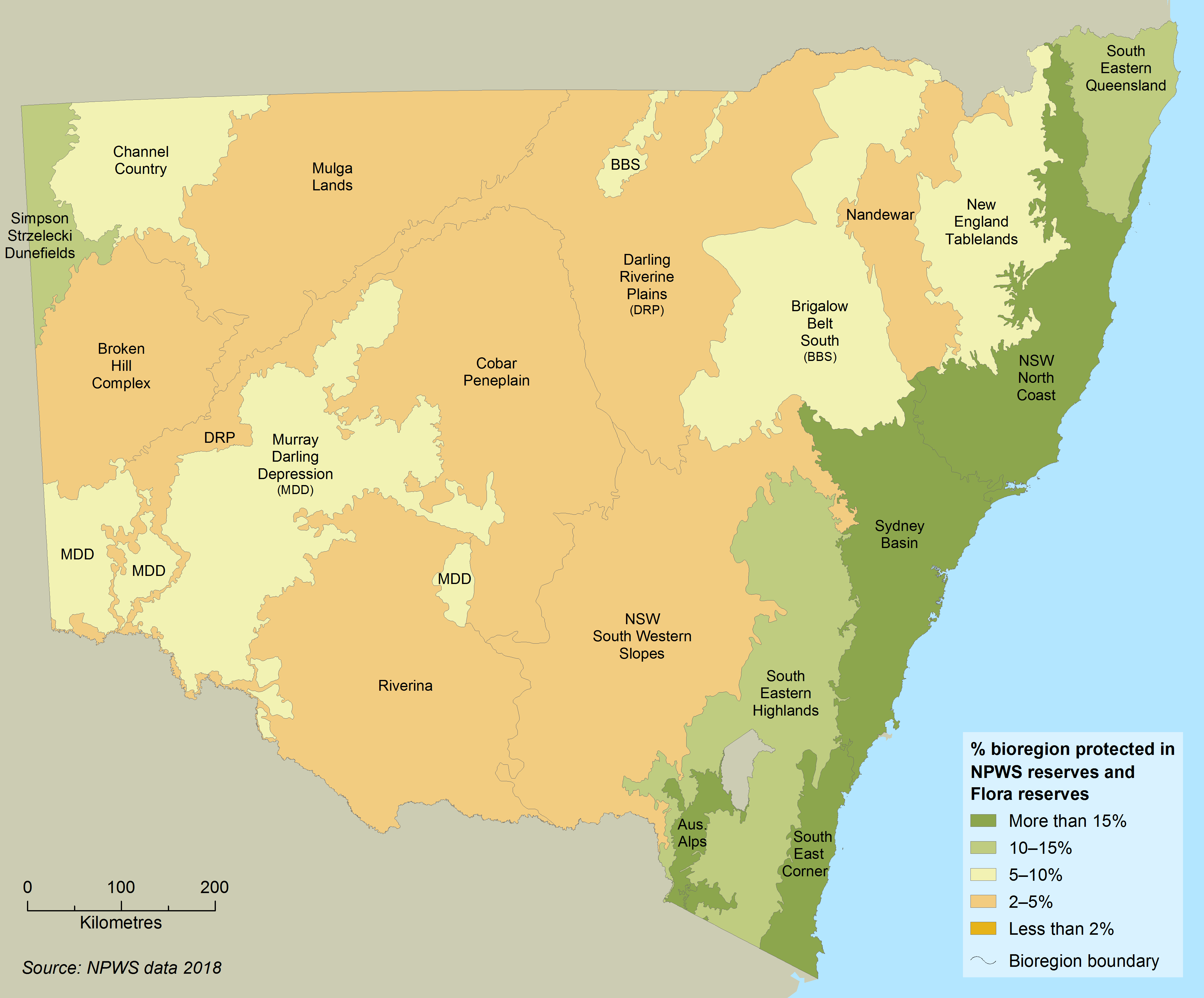
The reason for targeting central and western NSW is that it is under-represented in the protected area network compared to eastern NSW. While eastern NSW bioregions have national parks and reserves covering more than 70% of the land mass, some bioregions in central and western NSW are less than 10%. See NSW State of Environment report map of 2018 NSW Bioregions 2018
The new Western Project aims to utilise digital information as much as possible. It will involve NPA gaining a GIS (Geographic Information System) commonly used to create and manipulate maps often seen in publications, smartphones and navigation system in cars. The project will also utilise the vast amount of digital data on the NSW Government system named SEED https://www.seed.nsw.gov.au/ . SEED is a centralised resource for sharing and enabling environmental data in NSW.
The purpose of utilising GIS and digital data is to identify environmental values across the bioregions in the central and western divisions of NSW. One outcome will be an analysis of the current protected area network (e.g. national parks and reserves) and the identification of gaps in reaching certain targets such as the percentage or hectares under management protection. This will allow the NPA to gain an advocacy role in promoting protection measures in specific locations where current outcomes are below a target.
Ideally the Western Project will also use a DSS (Decision Support System). DSS is becoming more common in everyday life behind the scenes of digital mapping products. An example is car navigation units where GIS maps and site-specific details are an underlay and the route you choose between two locations is provided by a DSS. A user might want the quickest route, with tolls, on sealed roads. Alternatively, the DSS can identify a route with different user preferences such as shortest route, no tolls and any road surface.
The use of a DSS with the Western Project will be to consider different arrangements of what a protected area network might look like. An example might be to identify what 30% of a bioregion might look like if protected areas were to cover known locations of certain threatened species, together with certain vegetation communities, with each discreet area being over a certain size and linked with wildlife corridors. The DSS would then use the various data layers and records for each item and construct a map. Outcomes can be altered by changing each of the variables.
The aim is to recruit a project officer who would develop the skills needed to use the digital software. Those skills will also be useful for the NPA is other areas such as the creation of maps for publications or submissions.
A level of community engagement will also be initiated to allow community groups or individuals an insight into the project but also to utilise the store of community held information.
A project team has been established and may change over time as certain skills or experiences are drawn into the project. In addition, while an NPA budget is needed to commence the project, funding partners and/or benefactors will be necessary for the projects full potential to be realised. It is expected the project will run for a few years.